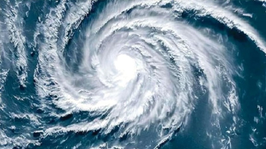
The Bangladesh Meteorological Department has reported the formation of a new low-pressure system in the Bay of Bengal, following the recent dissipation of an earlier low-pressure area. The agency noted that the current system could intensify into a depression, although it is not yet clear whether it will develop into a cyclone.
The low-pressure system emerged on Friday, October 24, at 6:00 a.m. in the southeastern Bay of Bengal. Meteorologists said the previous low-pressure system, formed just four days earlier, quickly weakened and had no impact on the Bangladesh coast.
Preliminary assessments suggest that the new system is unlikely to have a major effect on Bangladesh. However, it may bring rainfall to coastal regions and other parts of the country by the end of the week.
Kazi Zebunnesa, a meteorologist at the department, said, “The low-pressure system may intensify into a depression. Its main impact is expected along the Odisha coast in India. Some rainfall can also occur in Bangladesh.”
She added that the system’s precise path remains uncertain. Like its predecessor, it could weaken before reaching Bangladesh or develop into a depression. Further monitoring over the next few days will determine whether it evolves into a cyclone.
Meanwhile, the country has experienced a week of dry weather, causing temperatures to rise. The highest temperature recorded yesterday was 36.2 degrees Celsius in Feni, with light rainfall reported in Rangamati (9 millimeters) and minor showers in Srimangal.
Kazi Zebunnesa noted, “If the low-pressure system develops into a depression, some rainfall is likely in Bangladesh’s coastal areas and other regions around Wednesday.”


